
UMASS POND CROSSING
Field
Architecture, Structural Design
Focus
Accessibility, Historical Preservation, Campus Iconography
Location
Amherst, MA
Fall 2023
project information.
The UMASS Pond Crossing project was inspired by the University's Campus Master Plan (2012), which proposed
the addition of a bridge across the campus pond. The bridge would serve as a continuation of the historic Ellis Way, a previous organizational element of the campus that has since become neglected. As the pond serves as a key part of the campus image and history, any changes made to the area need to consider the impact on surrounding buildings and vegetation. However with the pond being located in the center of campus, it becomes extremely congested throughout the day. Additionally, the site accounts for some significant grade changes. Any new additions to this area should be considerate of these issues and use new construction as an opportunity to resolve these complications.
While my design recognizes this priority of reestablishing the connection to Ellis Way, I wanted to be very mindful of how the installation of a bridge could reinvent the pond as the iconic and memorable image of campus, while additionally serving students and faculty in the most efficient and practical sense. In order to achieve this, I focused on understanding the space through four conditions- pedestrian traffic, accessibility, recreational space, and campus image. These conditions allowed me to understand the best gestures the bridge could make by cutting across the pond in order to reactivate unused space and alleviate pedestrian congestion.
CAMPUS MASTER PLAN (2012) - PROPOSED BRIDGE
diagrams.


process work.
After analyzing my four main conditions, a form
representing three channels of movement began to materialize. The idea behind these paths was to achieve both efficiency and leisure, allowing users to pick the route most suited to them.
As my design developed, the focus became on the
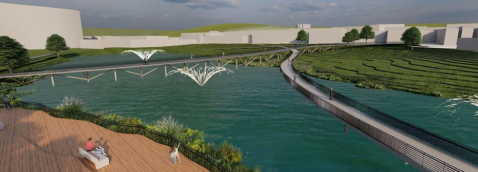
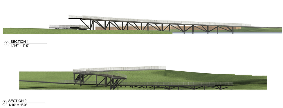
two longer paths, ensuring they began and ended at convenient, highly used walkways and properly addressed the grade changes. As the southeast side of the pond experiences a steep incline, it became logical to carry that height across the pond, crossing one bridge over the other and creating these beautiful views of the surrounding buildings, as well as of the lower bridge.
While both the upper and lower bridges maximize
walking efficiency, what was once the third aspect of the bridge became a riverwalk, upholding that priority of leisure and connecting people back to their natural surroundings. The form of the riverwalk follows existing topography lines, becoming a more natural body contrasting against the clean lines of the bridges.


RENDERED SITE PLAN
1/32" = 1'0"
- Riverwalk shape follows topography lines, creating an organic form in contrast with the stark lines of the bridges
- Preserve majority of existing trees

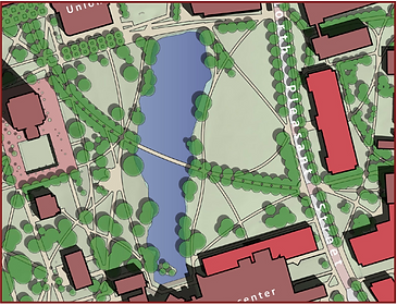
LOCATION SITE PLAN
1/64" = 1'0"
- Top bridge as an extension of historic Ellis Way
- Numbers associated with rendered views
final site plans.
sections.
renders.


